
Ionian Islands, also known as Eftanisa (Seven Islands)

Scroll down to view all the islands or click the one you want
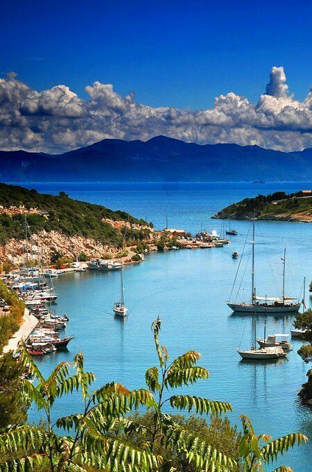
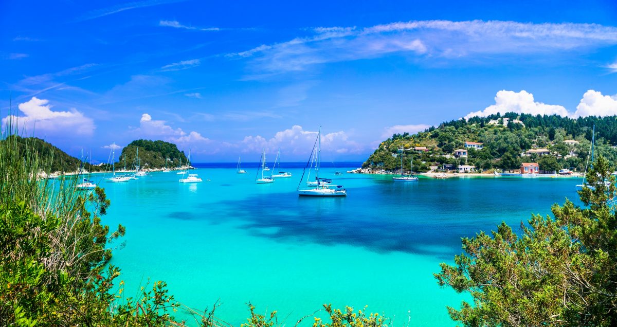
Kerkyra (Corfu) Island
Geography & Nature
Corfu is often called the “Emerald Island” because it is significantly greener than the arid islands of the Aegean (like Mykonos or Santorini).
Flora: It is home to over 2 million olive trees and lush cypress forests.
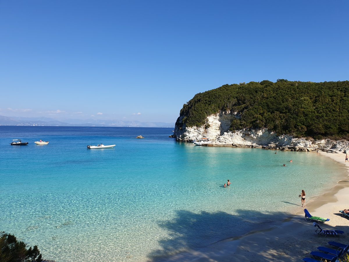
Terrain: The north is dominated by Mount Pantokrator, offering rugged cliffs and pebbled coves, while the south features flatter landscapes and expansive sandy beaches.
The Corfu Trail: A famous 220km long-distance hiking path that spans the entire length of the island.
Top Attractions
Corfu (Kerkyra) is a blend of Venetian elegance, Byzantine history, and rugged Ionian beauty. If you’re planning a visit in 2026, here are the landmark sites that define the island’s character.
Corfu (or Kerkyra in Greek) is often called the “Emerald Isle” of the Ionian Sea. Unlike the arid, white-washed landscapes typically associated with the Aegean islands, Corfu is defined by its lush greenery, vast olive groves, and a heavy Venetian influence that makes it feel as much Italian as it does Greek.
The Fortifications of Corfu Town
- The Old Fortress (Palaio Frourio): This Venetian masterpiece sits on a rocky peninsula separated from the town by a sea moat (the Contrafossa). It offers 360-degree views of the Ionian Sea and Albania. Don’t miss the Church of St. George, which looks more like an ancient Greek temple with its Doric columns.
- The New Fortress (Neo Frourio): Perched above the Old Port, this massive stone complex was built to protect the city from Ottoman invasions. It’s a maze of tunnels and bastions, and while it’s “newer” than its counterpart, it still dates back to the 16th century.
Palatial Estates
- Achilleion Palace: Built by Empress Elisabeth of Austria (Sisi) as a tribute to Achilles, this neoclassical palace is famous for its “Dying Achilles” statue and tiered gardens. Note: Parts of the interior may still be undergoing meticulous restoration, but the gardens and the iconic terrace overlooking the coast remain fully accessible and are the highlights of the estate.
- Mon Repos Estate: Located in the Kanoni area, this was the birthplace of the late Prince Philip, Duke of Edinburgh. Today, it houses an archaeological museum surrounded by lush parkland and ancient ruins of the city of Paleopolis.
Religious & Iconic Scenic Spots
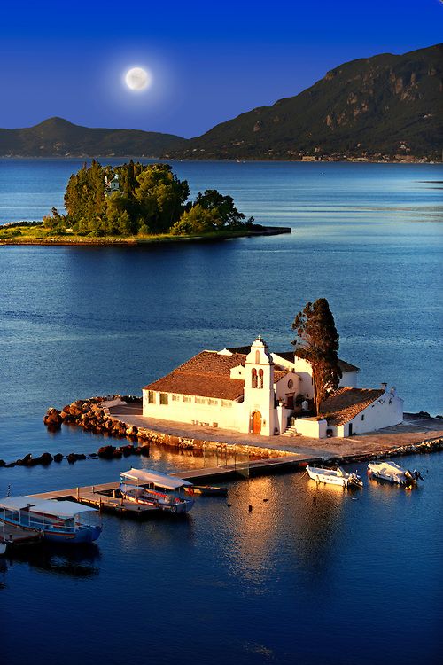
- Vlacherna Monastery & Mouse Island (Pontikonisi): This is the “postcard” view of Corfu. The tiny white Vlacherna monastery is connected to the mainland by a narrow pier in the Kanoni area. From there, you can take a small boat to Mouse Island, which myth says is the ship of Odysseus turned to stone.
- Paleokastritsa Monastery: Perched on a verdant hill above the turquoise bays of the west coast, this 13th-century monastery is dedicated to the Virgin Mary. It features a small museum, a traditional olive oil press, and incredible coastline views.
- Saint Spyridon Church: Located in the heart of the Old Town, its red-domed bell tower is the tallest on the island. It houses the silver casket of the island’s patron saint, Spyridon, who is credited with saving Corfu from famine and plague multiple times.
Town Squares & Architecture
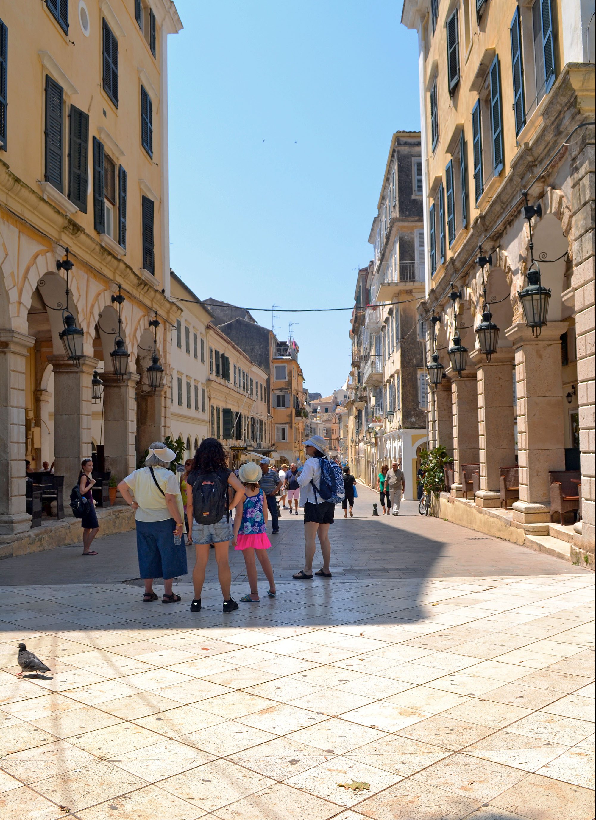
- Spianada Square & The Liston: The Spianada is one of the largest town squares in Europe. Adjacent to it is the Liston, an elegant arched colonnade inspired by the Rue de Rivoli in Paris. It’s the place to sip a ginger beer (tsitsibira) and watch local life.
- Palace of St. Michael and St. George: A grand Regency-style building at the north end of the Spianada that once housed British governors. It now contains the Museum of Asian Art, which is unique in Greece.
Northwest Landmarks
- Angelokastro (Angel’s Castle): A Byzantine fortress standing on a steep cliff 300 meters above the sea. It was never conquered and served as a vital lookout for centuries. The climb is steep but short (about 15 minutes).
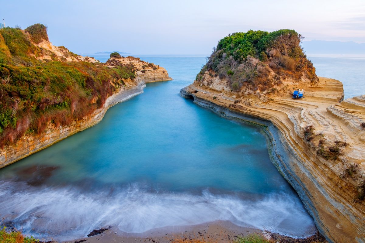
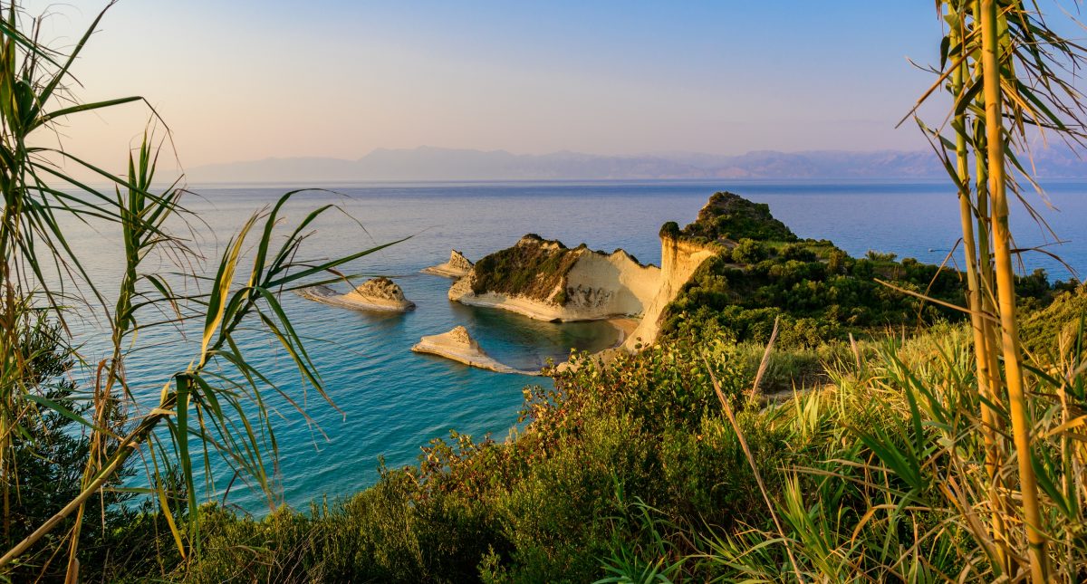
- Canal d’Amour (Sidari): Famous for its unique sandstone rock formations. Local legend claims that couples who swim through the channel together will stay in love forever.
Corfu, known in Greek as Kerkyra, is one of Greece’s most distinct and popular islands. Located in the Ionian Sea, it is famous for its “emerald” green landscapes, a unique blend of European cultural influences, and a history that remarkably avoided Ottoman rule.
Cultural & Historical Identity
Unlike most of Greece, Corfu was never occupied by the Ottomans. Instead, it was shaped by centuries of Venetian, French, and British rule, which created a unique “West meets East” atmosphere.
Venetian Legacy: Seen in the pastel-colored buildings, narrow alleys (kantounia), and the two massive fortresses in Corfu Town.
British & French Influence: The Liston Promenade was inspired by the Rue de Rivoli in Paris, and you’ll even find a cricket green in the center of the town—a nod to British heritage.
UNESCO Old Town: The entire Old Town of Corfu is a UNESCO World Heritage site, recognized for its architectural integrity and historical significance.
Geography & Nature
Corfu is often called the “Emerald Island” because it is significantly greener than the arid islands of the Aegean (like Mykonos or Santorini).
Flora: It is home to over 2 million olive trees and lush cypress forests.
Terrain: The north is dominated by Mount Pantokrator, offering rugged cliffs and pebbled coves, while the south features flatter landscapes and expansive sandy beaches.
The Corfu Trail: A famous 220km long-distance hiking path that spans the entire length of the island.
The island is shaped like a sickle and is characterized by its high rainfall (mostly in winter), which supports over four million olive trees.
Mount Pantokrator: The highest peak (2,972 ft), offering views across the sea to Albania and even Italy on exceptionally clear days.
Coastal Variety: The northern coast is rugged with dramatic cliffs and sea caves, while the southern part of the island is flatter with large sandy dunes and the protected Lake Korission lagoon.
Flavors of Corfu
Corfiot cuisine is heavily influenced by Italy. You must try:
Pastitsada: A hearty pasta dish with rooster or beef in a spicy tomato sauce.
Sofrito: Thinly sliced veal cooked in a white wine, garlic, and parsley sauce.
Kumquat: The island’s signature fruit, used to make liqueurs, marmalades, and sweets.


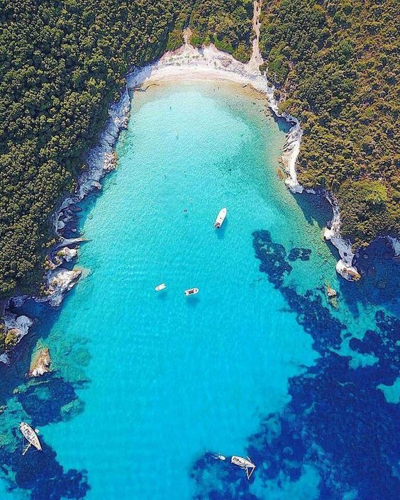
Paxos & Antipaxos Islands

Paxos and Antipaxos are both called Paxi (plural of Paxos in Greek).
Paxos Island
Often called the “secret garden” of the Ionian Sea, Paxos is the smallest of the main Ionian Islands. It is located just south of Corfu and is widely considered one of the most authentic and tranquil destinations in Greece.
Measuring only about 10 km long and 4 km wide, Paxos has managed to avoid mass tourism largely because it has no airport; visitors must arrive by boat or hydrofoil from Corfu or the Greek mainland (Igoumenitsa).
Geography & Landscape
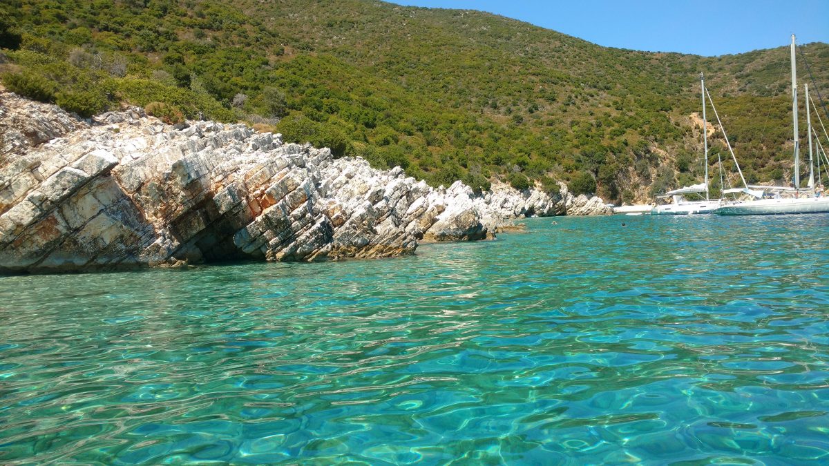
The East Coast: Characterized by gentle, sloping hills and pebble beaches. This is where the three main coastal villages are located.
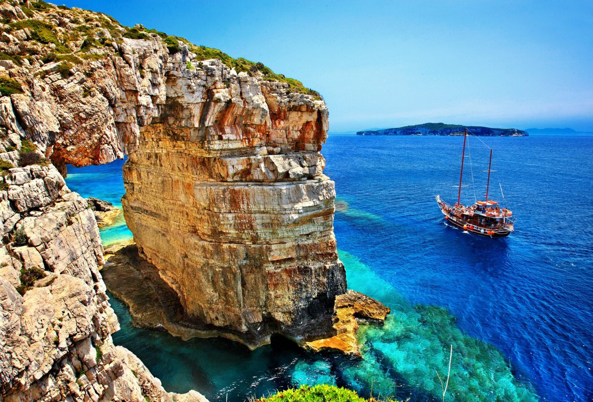
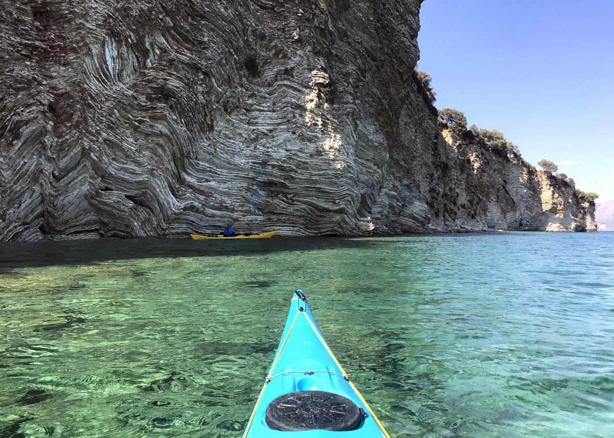
The West Coast: Dominated by dramatic white limestone cliffs, massive sea arches, and the famous Blue Caves accessible only by boat.
Olive Groves: The island is covered in roughly 200,000 olive trees, some of which were planted during the Venetian era and are centuries old.
The Three Main Villages
Life on Paxos centers around three coastal villages, each with its own distinct personality:
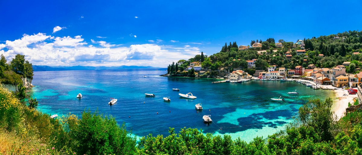
Gaios (The Capital): A bustling, colorful port protected by the islet of Agios Nikolaos. It features Venetian-style architecture, narrow alleyways, and a vibrant waterfront filled with cafes and tavernas.
Lakka: Tucked into a horseshoe-shaped bay at the northern tip. It is a favorite for sailors and yachties due to its calm, turquoise waters and sheltered harbor.
Loggos: The smallest and arguably most picturesque of the three. This tiny fishing village is famous for its high-quality seafood restaurants and laid-back, intimate atmosphere.
Highlights & Things to Do
Antipaxos: Just a 15-minute boat ride away, this even smaller sister island is home to Vrika and Voutoumi, often cited as some of the most beautiful sandy beaches in Europe with Caribbean-clear water.
The West Coast Sea Caves: Accessible only by boat, the western cliffs are dramatic and white, featuring the famous Blue Caves and the Tripitos Arch, a massive natural limestone bridge.
Olive Groves: The island is covered in over 200,000 ancient olive trees, some centuries old. Hiking through these groves via old donkey paths is a popular way to explore the island’s interior.
Erimitis Beach: A stunning beach on the west coast formed by a cliff collapse in 2008. It is one of the best spots on the island to watch the sunset.
Local Flavors
The island’s culture is a blend of Greek and Venetian influences, which extends to its food:
Paxos Olive Oil: Renowned as some of the highest quality in Greece.
Seafood: Freshly caught red mullet, lobster, and octopus are staples in the tavernas of Loggos and Gaios.
Local Wine: Produced in small quantities, primarily on the island of Antipaxos.
Travel Essentials
- Getting There: Most visitors arrive via hydrofoil (1 hour) or ferry (1.5–2 hours) from Corfu Town or the mainland port of Igoumenitsa.
- Getting Around: Renting a small motorboat is the most popular way to explore, as it allows you to reach hidden coves and Antipaxos at your own pace. On land, scooters and e-bikes are common.
Best Time to Visit
May to June & September: The ideal window. The weather is warm enough for swimming, but the island is peaceful and less crowded.
July & August: The peak “cosmopolitan” season when the harbors are full of yachts and the villages are at their liveliest.
Vibe: Sophisticated and peaceful. It’s perfect for couples and families who prefer quiet dinners and nature over nightlife.
Antipaxos Island
Antipaxos (also known as Antipaxoi) is a tiny, emerald gem in the Ionian Sea, located just 1.2 miles south of its “big brother” island, Paxos. Often described as the “Caribbean of Greece,” it is famous for having some of the most translucent, turquoise waters in the Mediterranean.
At a Glance
- Size: Approximately 4 $km^2$.
- Population: Fewer than 30–50 permanent residents.
- Landscape: Thick with vineyards, olive groves, and dramatic limestone cliffs.
- Vibe: Unspoiled and tranquil. There are no shops, no hotels, and no real villages—just a handful of scattered cottages and seasonal tavernas.
Main Beaches
- Vrika: A wide, white-sand beach with shallow, neon-blue water; home to a couple of tavernas.
- Mesovrika: A smaller, pebbly cove situated between the two main beaches, offering a more rugged feel.
- Voutoumi: Widely considered one of the most beautiful beaches in Europe, featuring electric-blue water and a pebble-to-sand transition.
- Rodovani: A more secluded, rocky bay on the west coast, typically reached by private boat or a long hike.
Beyond the Beach
While the water is the main draw, the island’s interior offers a different kind of charm:
- Vineyards: The island is covered in vines producing local varieties like Mavrodaphne. You can wander the paths through the vineyards, which feel like a step back in time.
- Hiking: You can hike to the Akra Ovoros Lighthouse at the southern tip for rugged coastal views.
- Snorkeling: The visibility is incredible (up to 50 meters), making the sea caves and rocky edges near Voutoumi a haven for marine life.
Practical Travel Tips
- Getting There: Most people take a water taxi from Gaios (Paxos), which takes about 15 minutes and costs roughly €20–€25 round-trip. Larger excursion boats also run from Corfu and Parga.
- No Shops: There are no mini-markets. If you need snacks, sunscreen, or specific supplies, buy them in Paxos before you board.
- Accommodation: It is nearly impossible to stay overnight unless you book one of the very few private villas months (or even a year) in advance. Most people visit as a day trip.
- Timing: The island is “active” only from May to September. In the winter, the tavernas close, and the island becomes almost entirely deserted.
Things to Do
- Snorkeling: The underwater visibility is exceptional, especially around the rocky edges of Mesovrika, and sandy beaches of Vrika and Voutoumi, where the water is a vivid electric blue.
- Hiking: Walk the path up to Bella Vista for a panoramic view of the coastline and the Ionian Sea.
- Wine Tasting: Visit a local vineyard or enjoy a glass of the island’s rare red wine with a seafood lunch.
To explore the beautiful bay of Paxi islands and other Ioanian Islands, just go to Google Maps below, click the satellite square in the lower left side. Then zoom in to see the spectacular and many unknown bays in Paxos and Antipaxos islands.
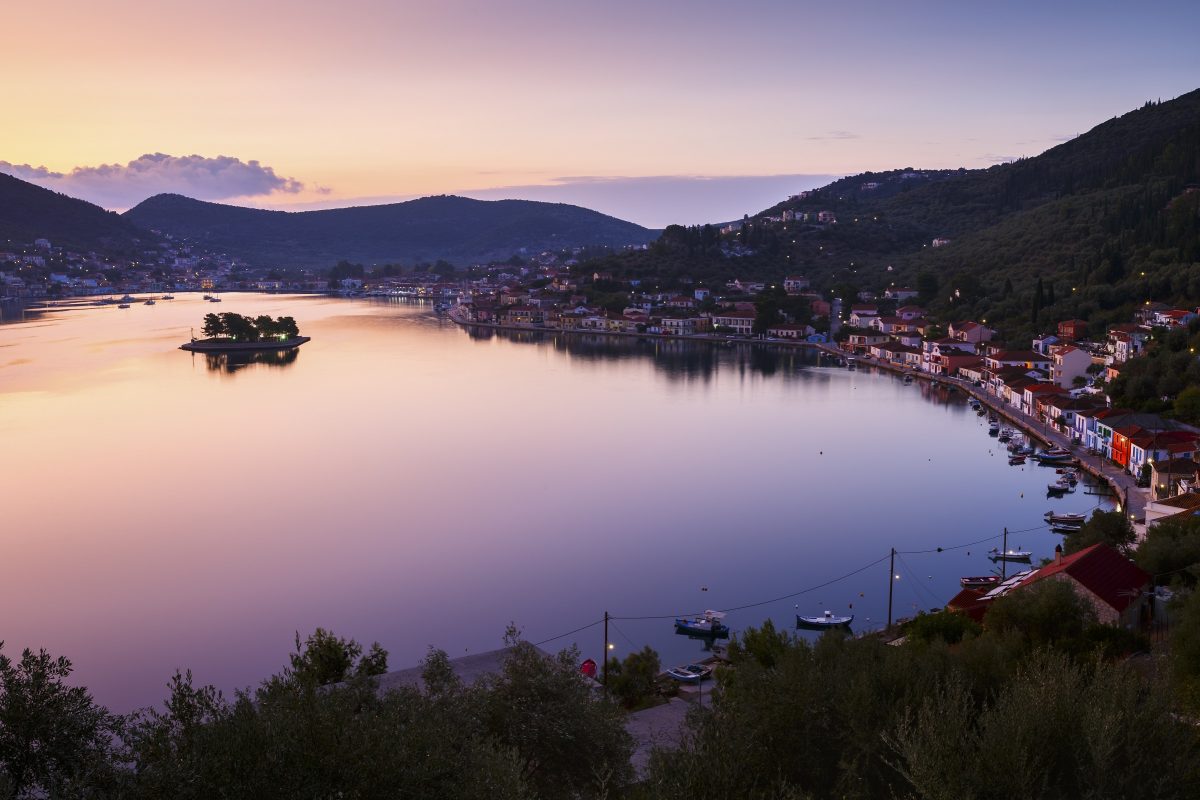
Lefkada Island

Lefkada is the only Greek island you can actually drive to, thanks to its floating bridge connection to the mainland. Once you’re across, you’ll find a landscape defined by dramatic white cliffs and water so turquoise it looks like someone left a saturating filter on.
Here are the must-see attractions on Lefkada, ranging from world-famous coastlines to quiet mountain escapes.
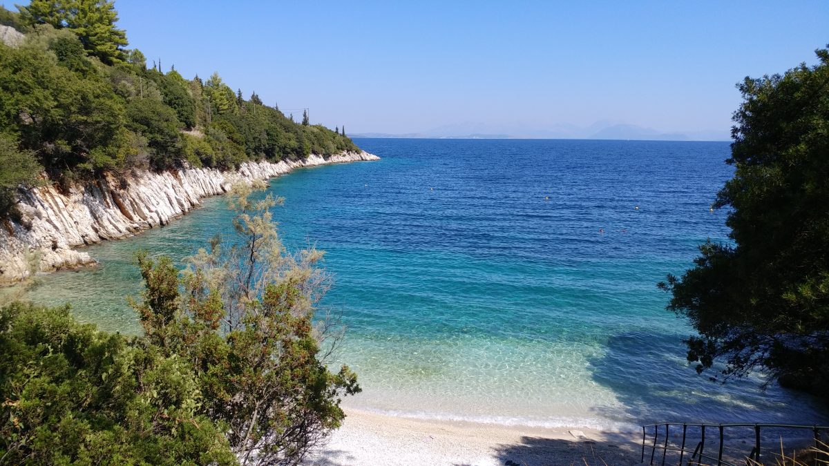
The Iconic West Coast Beaches
The west coast is where you’ll find the “Caribbean of Greece” views. These are the heavy hitters:
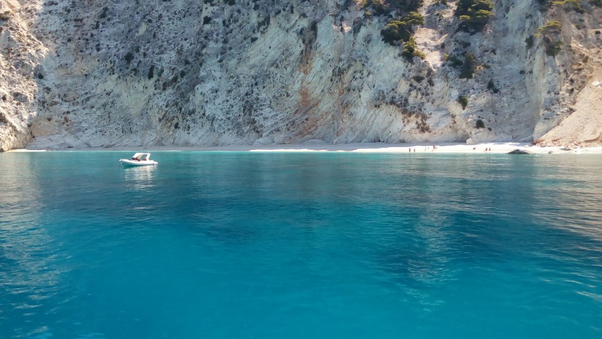
- Porto Katsiki: Often cited as one of the best beaches in the Mediterranean. It’s framed by a massive crescent of white limestone cliffs. You’ll descend about 80 steps to reach the shore, where the contrast between the white pebbles and electric blue water is genuinely jaw-dropping.
- Egremni Beach: Known for being even more wild and expansive than Porto Katsiki. After the 2015 earthquake, access was restricted for years, but it’s back. It features a long staircase (over 300 steps) or can be reached via boat. It feels more remote and less crowded than its neighbor.
- Kathisma Beach: The most “organized” of the big west coast beaches. It’s easily accessible by car and features beach bars, sunbeds, and even paragliding for the adrenaline junkies who want to see the blue from above.
- Mylos Beach: Located near the village of Agios Nikitas, this one requires a bit of effort—either a 15-minute hike over a hill or a quick water taxi. The reward is a pristine, wide beach that feels much more secluded.
Charming Villages & Towns
- Lefkada Town: The island’s capital is full of color. Walk through the pedestrian “steno” (main street) to find boutique shops, vibrant bars, and the unique architecture of the wooden-framed houses built to withstand earthquakes.
- Agios Nikitas: A traditional fishing village turned into a car-free pedestrian haven. It’s the perfect spot for a sunset dinner at a taverna right by the water.
- Karya: For a break from the heat, head into the mountains. Karya is famous for its traditional embroidery, ancient plane trees in the central square, and a much cooler breeze.
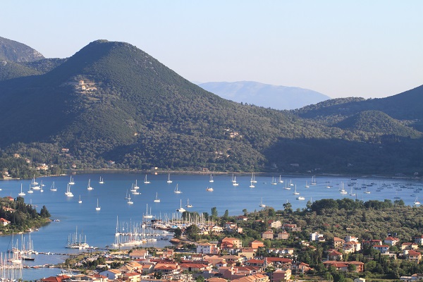
- Vasiliki: A paradise for windsurfers located in the south. Even if you don’t sail, the harbor is lined with excellent seafood restaurants and offers a very relaxed, sporty vibe.
Natural & Historical Landmarks
- Cape Lefkatas (Cape Doukato): The southernmost tip of the island. It’s home to a lonely white lighthouse standing where a temple to Apollo once was. Legend says the poetess Sappho jumped from these cliffs. The views of Kefalonia and Ithaca from here are unbeatable.
- Nydri Waterfalls (Dimosari): A refreshing escape from the salt and sun. A short, easy hike through lush greenery leads you to a series of waterfalls and natural pools where you can take a (very cold) dip.
- Faneromeni Monastery: Perched on a hill overlooking Lefkada Town and the lagoon. It’s the religious heart of the island and features a beautifully kept garden and a small animal sanctuary.
- Castle of Agia Maura: Located right at the entrance of the island. This 14th-century fortress was built to protect the capital from pirates and invaders and is a great spot for a walk before you head deeper into the island.

Kefalonia Island
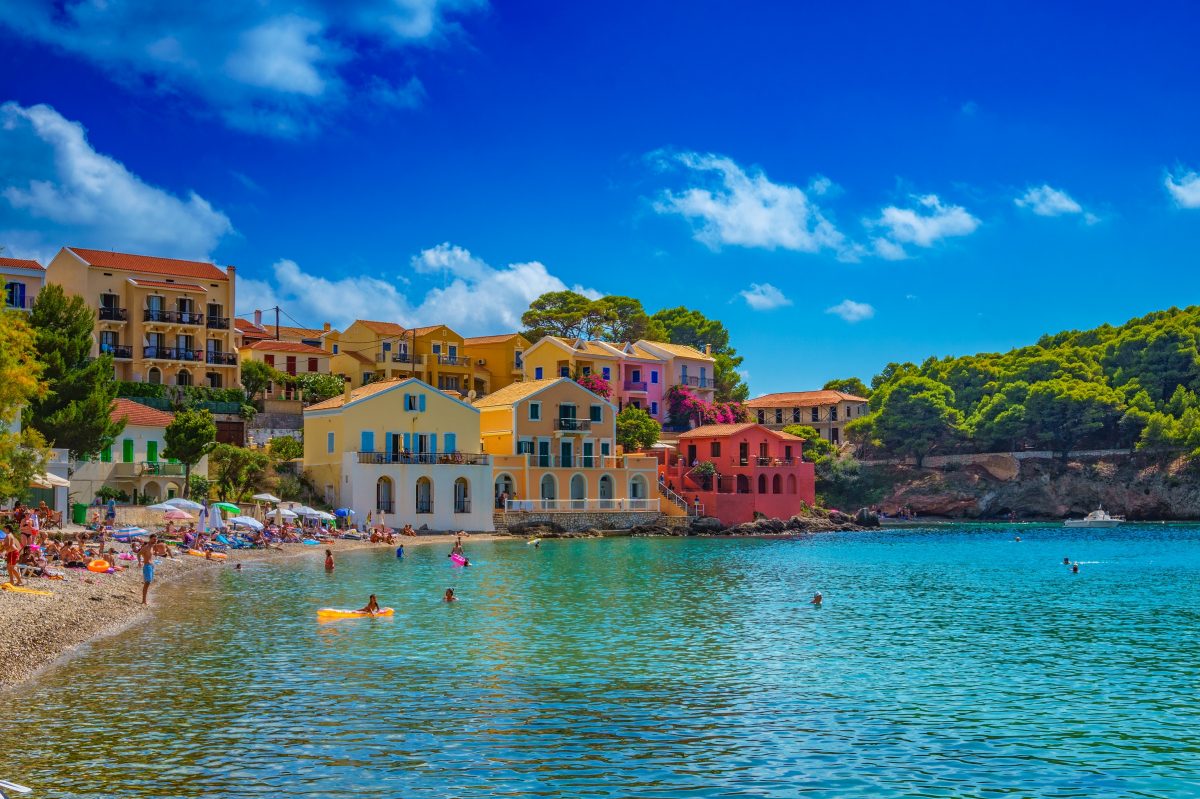
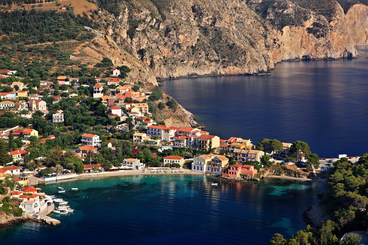
Kefalonia (or Cephalonia) is the largest and most diverse of the Ionian Islands, known for its dramatic limestone cliffs, majestic mountains with lush greenery, and turquoise waters. It gained international fame as the setting for the novel and film Captain Corelli’s Mandolin.
With an area of 300 sq miles and unique shape Kefalonia feels spacious and rugged, offering everything from sophisticated yachting harbors to “ghost villages” abandoned after the 1953 earthquake.
Geography & Landscapes
-
Total Surface Area: Approximately 300 square miles, making it the largest of the Ionian Islands.
-
The Ainos (Enos) Mountain Range: Dominating the center-south of the island, Mount Ainos is the highest peak in the Ionian islands, reaching 5,340 feet. It is a National Park and home to the rare Abies cephalonica (Kefalonian Fir) tree.
-
The Paliki Peninsula: A distinct, flatter western wing of the island separated from the main body by the Gulf of Argostoli. It has a more pastoral, clay-rich landscape compared to the rest of the island’s limestone.
-
Coastline Variety: The island features over 250 km of coastline, alternating between steep white cliffs in the north and west and gentler, sandy shores in the south.
Natural Wonders
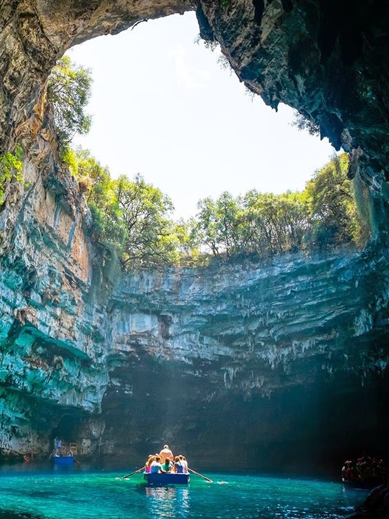
- Melissani Lake Cave: An underground lake where the roof collapsed centuries ago. When the sun is overhead, the water glows an impossible shade of blue, making the rowboats look like they are floating in mid-air.
- Drogarati Cave: A 150-million-year-old cavern with impressive stalactites and stalagmites. Its “Chamber of Exaltation” has such incredible acoustics that it occasionally hosts concerts.
- Mount Ainos National Park: The highest peak in the Ionian, covered in unique Cephalonian Fir trees. It is a haven for hikers and home to a rare breed of semi-wild horses.
- Katavothres (Sinkholes): A geological phenomenon near Argostoli where seawater “disappears” into cracks in the earth, traveling all the way across the island underground to emerge in Melissani Cave.
Charming Villages
While much of the island was affected by a catastrophic earthquake in 1953, several villages retain their historic charm or have been beautifully rebuilt to reflect traditional Ionian architecture.
- Argostoli: The island’s capital. Walk the De Bosset Bridge (the longest stone bridge over sea in the world) to spot Caretta-caretta sea turtles following the fishing boats in the morning.
-
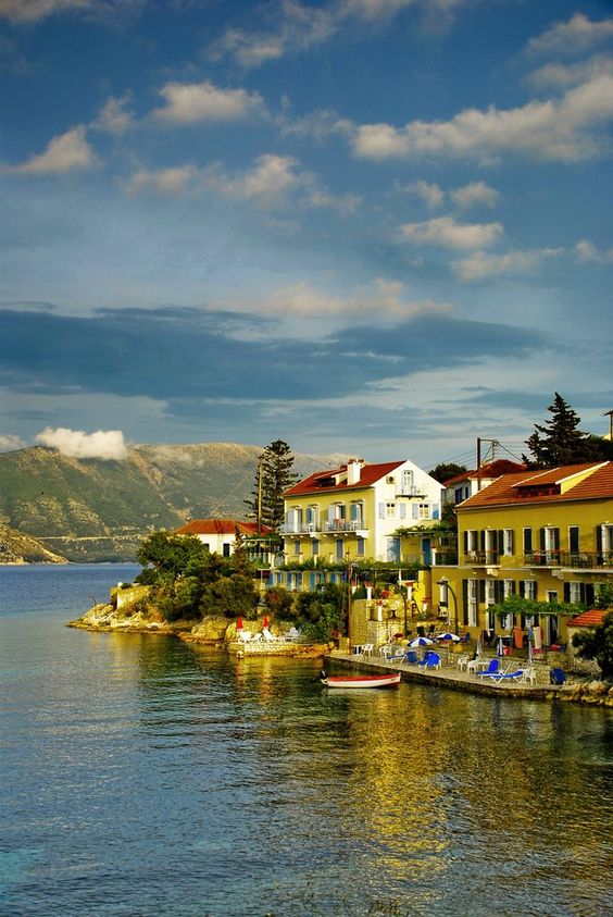
Fiskardo: Located on the northern tip, this is one of the few villages that survived the earthquake intact. It features colorful Venetian houses and a cosmopolitan harbor filled with yachts and waterfront tavernas.
-
Assos: A picturesque village built on a small peninsula, crowned by the ruins of a 16th-century Venetian castle and known for its pastel-colored houses and quiet bay.
-
Argostoli: The island’s bustling capital, where you can walk across the historic Drapano Bridge or spot Loggerhead sea turtles feeding in the harbor each morning.
- Sami: A busy port town with a beautiful waterfront, serving as the gateway to the island’s most famous caves and beaches.
Majestic Beaches
Kefalonia is famous for its dramatic coastline, featuring a mix of white-pebble bays with electric-blue water and long, sandy stretches. Here is a summary of the island’s best beaches, organized by their vibe and features. Tip: Most northern beaches (near Fiskardo) are pebbly, while the southern beaches (near Argostoli and Skala) tend to be sandier.The Iconic “Must-Sees”
These are the postcard-perfect beaches that define the island’s reputation.- Myrtos Beach: Often cited as one of the best in Greece. It features a mix of white pebbles and sand under towering limestone cliffs. The water is a striking milky-blue, though it drops off very steeply.
- Antisamos Beach: Known for its appearance in Captain Corelli’s Mandolin. It is a lush, green-fringed pebble beach with exceptionally calm, crystal-clear water—perfect for snorkeling and water sports.
- Petani Beach: Located on the Paliki peninsula, it is often compared to Myrtos but offers better sunsets. It has fine pebbles, clear turquoise water, and several traditional tavernas.
Sandy & Shallow
If you are traveling with children or prefer soft sand over pebbles, these are your best bets.- Makris Gialos: The most popular sandy beach near the capital, Argostoli. It has golden sand, shallow water, and full amenities including beach bars and water sports.
- Avithos Beach: A local favorite with soft sand and very shallow water, making it extremely safe for toddlers. It’s backed by low cliffs and features excellent seaside tavernas.
- Lourdas Beach: A long, spacious stretch of sand and fine shingle. It offers a relaxed atmosphere with plenty of sunbeds and easy access to nearby cafes.
- Skala Beach: A massive, several-kilometer stretch of sand and grit. Because of its size, it rarely feels crowded, even though it’s fully organized with every amenity imaginable.
Secluded & Adventurous
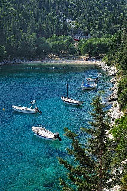
These beaches often require a boat, a hike, or a drive down steep, winding roads.- Fteri Beach: Arguably the most beautiful “wild” beach on the island. It is typically reached by a short water taxi from Zola. It has no facilities, just pure white pebbles and neon-blue water.
- Dafnoudi Beach: A hidden gem at the northern tip. You have to hike through a shaded forest path for about 15 minutes to reach this quiet, pebbly cove.
- Pessada Beach: A tiny, “secret” sandy cove reached via a steep set of stairs. It’s ideal for those who want to escape the crowds and enjoy a more rugged, local feel.
- Alaties Beach: A very small, rocky cove in the north. It’s famous for its salt-crusted rocks and is one of the best spots on the island to watch the sunset with a cocktail.
Unique Beaches
- Xi Beach: Famous for its burnt-orange/red sand and white clay cliffs. Visitors often rub the clay on their skin for a natural, DIY spa treatment. The water is exceptionally shallow for a long distance.
- Foki Beach: Located near Fiskardo, this beach is unique because the olive and cypress trees grow right down to the water’s edge, providing deep natural shade and a “fjord-like” feeling.
- Kaminia (Mounda) Beach: A protected nesting ground for Loggerhead (Caretta-caretta) sea turtles. It is a very long, quiet, and shallow sandy beach.
History & Culture
-
The 1953 Earthquake: This catastrophic event leveled almost every building on the island, forcing a massive wave of emigration. The island was rebuilt with a focus on traditional styles, though some ruins still remain as “ghost villages.”
-
Venetian Influence: Like the other Ionian islands, Kefalonia was never occupied by the Ottomans. Instead, it was ruled by Venice for centuries, which influenced the local dialect, music (Serenades), and architecture.
-
Patron Saint: St. Gerasimos is the protector of the island. His monastery is a central pilgrimage site, and his name is so popular that a large portion of local men are named “Gerasimos” (often shortened to Jerry or Makis).
Local Flavors
Kefalonia has a distinct culinary identity compared to the rest of Greece:
-
Robola Wine: A crisp, citrusy white wine made from grapes grown on the limestone slopes of Mt. Ainos.
-
Meat Pie (Kreatopita): A hearty traditional pie filled with three types of meat, rice, and spices.
-
Mandoles: Candied almonds, typically dyed a vibrant red using seaweed.
Nature & Wildlife
The island is a haven for biodiversity. It is one of the primary nesting grounds for the Caretta Caretta (Loggerhead) sea turtle, which can often be seen swimming in the Argostoli harbor near the fishing boats. You may also spot the rare Mediterranean Monk Seal in the secluded sea caves of the northern coast.

Melissani cave short video
Ithaca Island
Located in the Ionian Sea, Ithaca (or Ithaki) is a Greek island globally renowned as the mythical home of Odysseus, the hero of Homer’s Odyssey. Unlike its larger neighbors, Ithaca has resisted mass tourism, preserving a serene, rugged, and authentic atmosphere.
Often called the “Island of Odysseus,” Ithaca (or Ithaki) is a gem of the Ionian Sea. Unlike its larger, more bustling neighbor Kefalonia, Ithaca is known for its quiet, poetic atmosphere and its deep-rooted connection to Homer’s Odyssey.
Here is a breakdown of what makes Ithaca special:
Geography & Layout
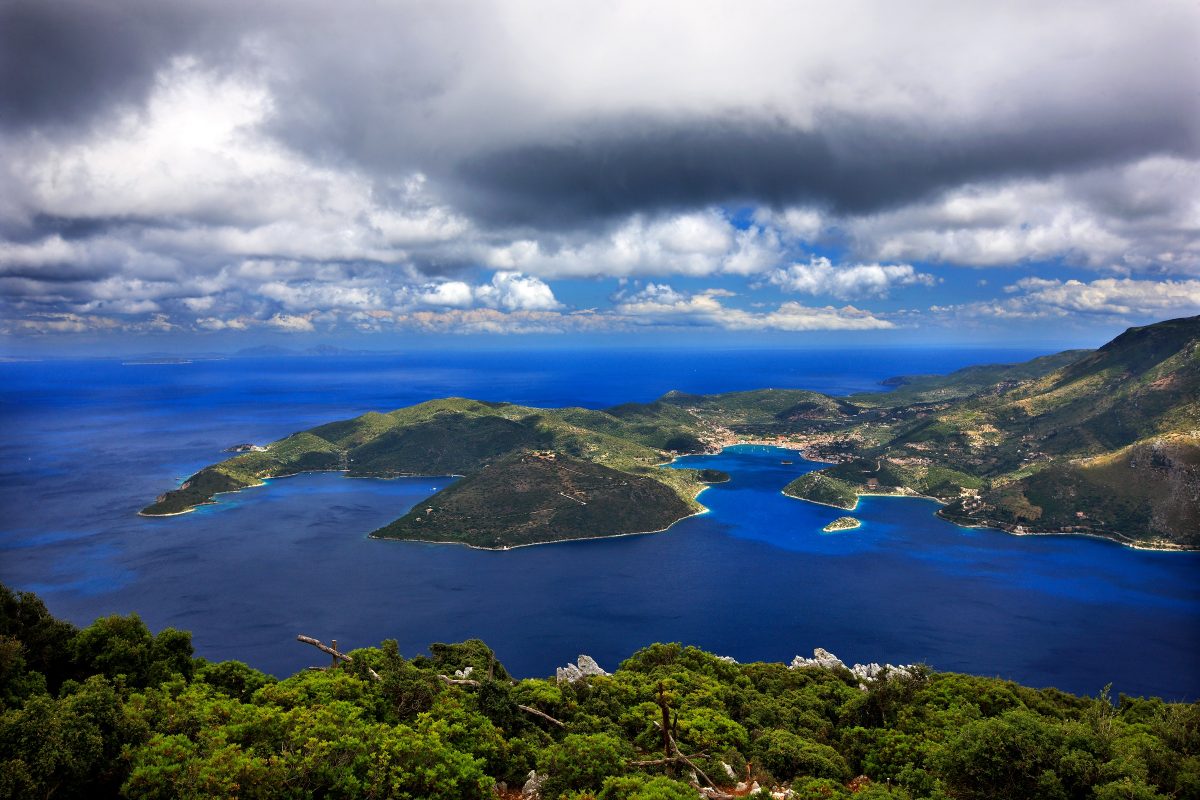
Ithaca is the second-smallest of the seven main Ionian Islands. It is uniquely shaped, consisting of two mountainous peninsulas connected by the narrow Isthmus of Aetos.
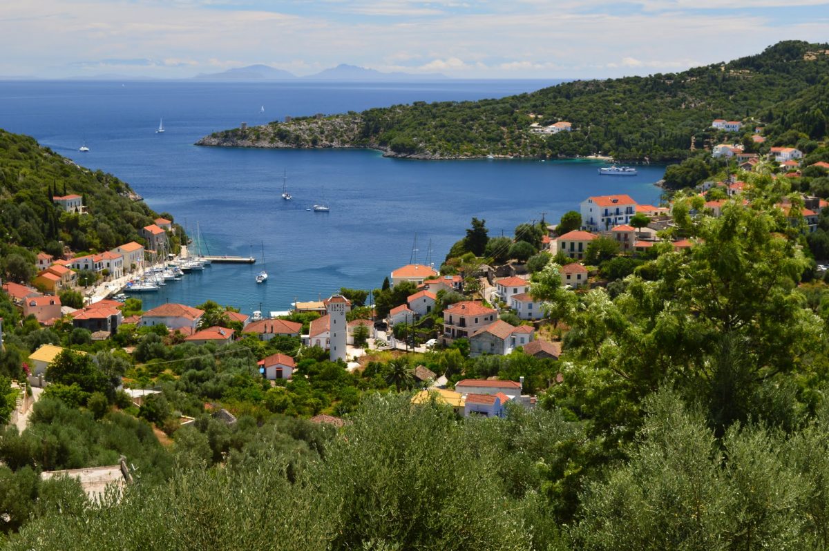
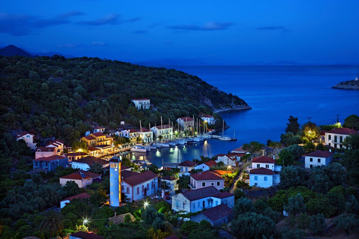
Vathy: The capital and main port, situated in a deep, fjord-like bay. It is famous for its red-tiled houses and traditional Ionian architecture.
The North: Home to picturesque villages like Kioni and Frikes, which are popular with the sailing community.
Terrain: The island is verdant and mountainous, with the highest peak, Mount Nirito, reaching 2,645 feet.
Myth & History
Ithaca is famously the homeland of the legendary hero Odysseus. While historians and archaeologists have long debated the exact location of his palace, the island is filled with sites that echo the epic poem:
The School of Homer: An archaeological site in the north where ruins of a large building complex suggest a Mycenaean palace.
The Cave of the Nymphs (Marmarospilia): According to legend, this is where Odysseus hid the treasures given to him by the Phaeacians.
Pilikata Hill: A site near Stavros village where excavations have revealed a Bronze Age settlement.
For thousands of years, Ithaca has been a symbol of “the journey home.”
Homeric Connection: While archaeologists have long searched for Odysseus’s palace, the island remains the spiritual heart of the Odyssey. Excavations at sites like School of Homer and Loizos Cave have yielded artifacts (like bronze tripods) that echo the epic poem.
Successive Rulers: Its strategic location led to various occupations, including the Romans, Byzantines, Normans, and most notably the Venetians (1503–1797), whose influence is still visible in the island’s culture and architecture.
Cavafy’s “Ithaka”: The island inspired one of the most famous Greek poems by Constantine Cavafy, which uses the journey to Ithaca as a metaphor for the pursuit of wisdom and experience.
Charming Towns & Villages
Vathy: The island’s capital and main port. It is a “traditional settlement” built amphitheatrically around a deep, fjord-like bay. Its colorful houses and waterfront cafes make it one of the most picturesque harbors in Greece.
Kioni: A stunning fishing village on the northeast coast. It survived the 1953 earthquake better than other parts of the island, preserving its original Ionian architecture.
Frikes: A smaller, laid-back fishing port popular with sailors and hikers.
Anogi: A mountain village known for its massive, naturally occurring monoliths (menhirs) and a 12th-century Byzantine church.
Main Attractions
Vathy Harbor & Lazaretto Islet: A stunning natural harbor featuring a tiny islet with a 17th-century church.
Kathara Monastery: Located at an altitude of $600$m, offering panoramic views of the entire Ionian archipelago.
Kioni Village: A “listed” traditional settlement with flower-filled patios and waterfront tavernas.
Cave of the Nymphs: A mythical site where Odysseus is said to have hidden his treasures upon his return from Troy.
Beaches: Known for crystal-clear, emerald waters and white pebbles. Notable spots include Gidaki (accessible by boat), Filiatro, and Afales.
Beaches & Nature
Ithaca’s coastline is characterized by emerald waters and white pebble beaches. Many are accessible only by boat or hiking trails, adding to their secluded feel:
Gidaki Beach: Often cited as one of Greece’s best, featuring bright turquoise water and a backdrop of steep cliffs. It is most easily reached by boat from Vathy.
Filiatro: The island’s most popular beach, offering a mix of vibrant beach bars and calm, clear water.
Sarakiniko: A tranquil, wild beach perfect for snorkeling.
Atmosphere & Activities
The island is a paradise for hikers and sailors. A network of ancient mule paths connects the villages, leading you through olive groves and offering panoramic views of the Ionian archipelago.
The vibe is distinctly low-key—it lacks the large resorts of other islands, making it a favorite for those seeking peace, authentic Greek cuisine, and “slow travel.”
Practical Information
- Getting There: There is no airport. Visitors typically fly to Kefalonia and take a short ferry (approx. 20–40 mins) or take a ferry from the mainland ports of Patras or Astakos.
- Atmosphere: It is a destination for “slow travel”—ideal for hiking, sailing, and quiet reflection rather than loud nightlife.

Zakynthos (Zante) Island
Zakynthos, also widely known by its Italian name Zante, is the third largest of the Ionian Islands in western Greece. Often called the “Flower of the East” (Fiore di Levante) by the Venetians, it is famous for its dramatic white limestone cliffs, turquoise waters, and as a major nesting ground for the endangered loggerhead sea turtle.
Today, it is a world-class travel destination that balances high-energy party hubs with tranquil, protected nature reserves.
Geography & Regions
The island’s landscape varies significantly from one coast to the other:
The West & North: Rugged, mountainous, and dominated by steep limestone cliffs that drop into the neon-blue Ionian Sea. This is where you find the famous sea caves and the most dramatic viewpoints.
The East & South: Flat, fertile plains filled with olive groves and citrus orchards, leading to long, shallow sandy beaches. This area is much more developed for tourism.
- The Interior: Dominated by olive groves, vineyards, and traditional stone-built villages.
Top Attractions
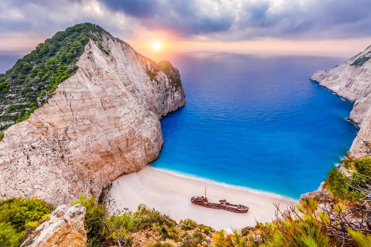
Navagio (Shipwreck) Beach: One of the most photographed beaches in the world. It features the wreck of the Panagiotis ship resting on white sands, framed by 200-meter-high cliffs. Arguably the most famous beach in Greece, this isolated cove features the wreck of the Panagiotis ship resting on white sands. It is surrounded by 200-meter-high cliffs and is only accessible by boat. Access to the sand is frequently restricted due to landslide risks, but boat tours still visit the bay for swimming.
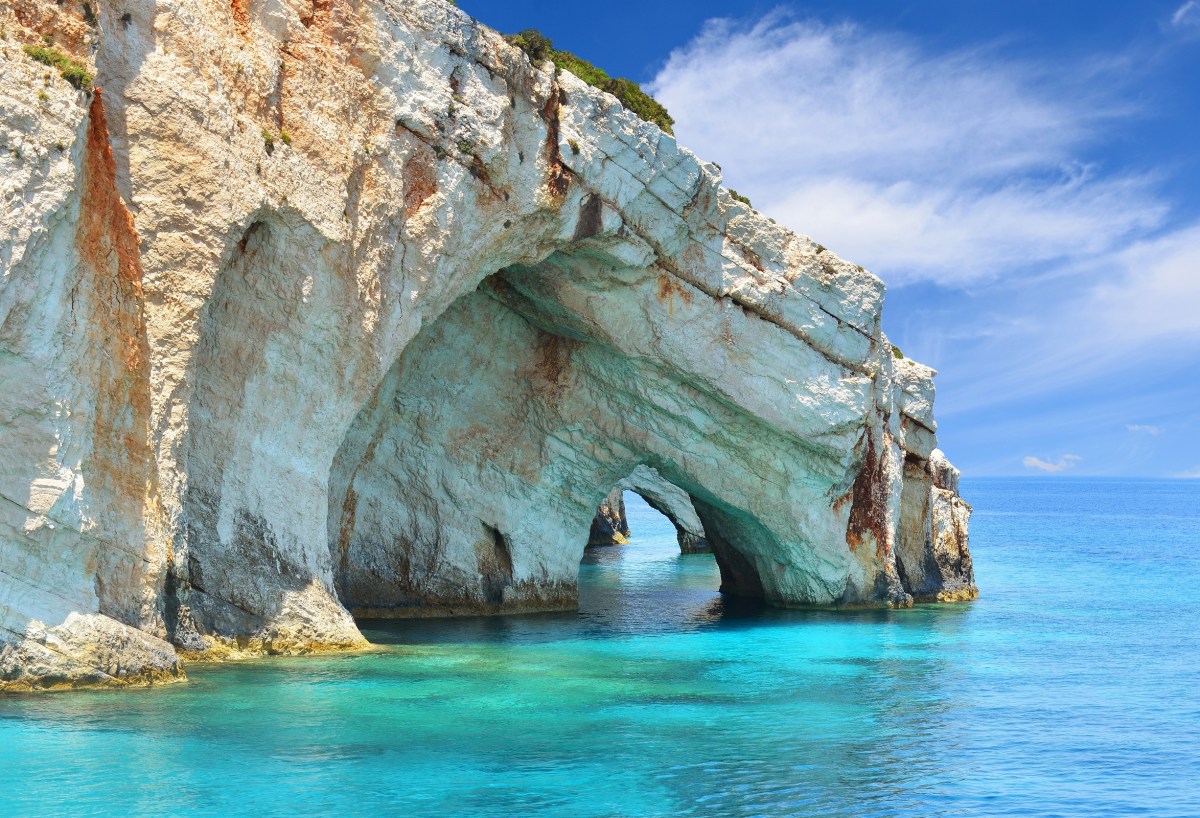
The Blue Caves: Natural sea arches and caves at Cape Skinari where the water glows with a luminous sapphire hue. Located at the northern tip near Cape Skinari, these natural arches and caverns are famous for the way the sunlight reflects off the white seafloor, turning the water an otherworldly shade of bright blue.
- National Marine Park (Laganas Bay): Zakynthos is one of the most important nesting sites in the Mediterranean for the Caretta-caretta (loggerhead) turtle.
Marathonisi (Turtle Island): An uninhabited islet in Laganas Bay shaped like a turtle. It serves as a major nesting ground for the endangered Caretta caretta (Loggerhead) sea turtles.
Zakynthos Town (Chora): The island’s cultural hub, rebuilt in traditional Venetian style after a devastating earthquake in 1953. Key spots include Solomos Square and the Church of Saint Dionysios. The capital was largely destroyed by a massive earthquake in 1953 but was rebuilt with its Venetian character in mind. Highlights include Solomos Square, the church of Agios Dionysios (the island’s protector), and the Bochali Hill viewpoint overlooking the harbor.
Keri Lighthouse & Myzithres Rocks: Located in the southwest, this spot offers legendary sunset views over two massive white sea stacks.
- Gerakas Beach: A protected, sandy peninsula at the southern tip where turtle nests are carefully monitored by volunteers.
Culture & Gastronomy
Zakynthian culture is a unique blend of Greek tradition and 400 years of Venetian influence, visible in both its music (Kantades folk songs) and its food.
Signature Dishes:
- Sartsa: Beef cooked with tomatoes, garlic, and local ladotyri cheese.
- Stuffed Rabbit: Usually slow-cooked in red wine or vinegar.
- Mandolato: A traditional chewy nougat made with honey, egg whites, and almonds.
Local Products: The island is famous for its Zante Currants (small seedless grapes), high-quality olive oil, and Verdea wine, a traditional white wine with a Protected Geographical Indication.
Culture & History
Venetian Influence: Unlike much of mainland Greece, Zakynthos was never under Ottoman rule. It spent centuries under Venetian, French, and British control, which deeply influenced its architecture, music, and dialect.
Music & Poetry: The island has a rich tradition of kantades (romantic serenades) and is the birthplace of Dionysios Solomos, the poet who wrote the Greek National Anthem.
Heroic History: During WWII, the Mayor and Bishop of the island famously refused to hand over a list of Jewish residents to Nazi occupiers, instead providing a list with only their own two names. Their bravery saved the entire Jewish community of the island.
Travel Tips
Best Time to Visit: May to June or September to October for pleasant weather without the extreme heat and peak-season crowds of July/August.
Getting Around: While there are buses, renting a car or ATV is highly recommended to reach the more secluded western viewpoints and mountain villages.
Wildlife Respect: If visiting Laganas or Gerakas beaches, follow all National Marine Park guidelines to protect turtle nesting sites (e.g., no bright lights or beach access after dark).
Best Time to Visit
May to June: Perfect for hiking and seeing the island’s lush greenery and wildflowers.
July to August: Peak season. High temperatures (30°C+) and heavy crowds, especially in party-centric areas like Laganas.
September to October: The sea is at its warmest, and the crowds begin to thin out.
If you are ready for the Ionian islands, reach out below …